George Davenport House Historical Report, Block 8 Building 27Originally entitled: "Draper House and Lot, Block 8 Capitol Square"
Colonial Williamsburg Foundation Library Research Report Series - 1123
Colonial Williamsburg Foundation Library
Williamsburg, Virginia
1990
DRAPER HOUSE AND LOT
(Block 8 Capitol Square)
1949 - 2nd Copy
| LOCATION: | On Francis Street near Capitol |
| HISTORY: | Chronological account from ca. 1780 to present - pp. 1-5 |
| SUMMARY: | pp. 5-6 |
| APPENDIX: | |
| Illustration #1 | - Maps |
| Illustration #2 | - Accounts with Humphrey Hardwood |
| Illustration #3 | - Williamsburg land tax records |
Draper lot (Block 8)
Additional findings, in chronological order:
The "Draper" lot, along with the lot west of it, was owned by George Wythe in 1749. See William Waller's map of that date, in map files.
Some time in the 1760s the lot was bought by George Davenport, an attorney and clerk to several of the committees of the house of burgesses. Davenport died in 1766, leaving his wife Catherine in possession of the house and lot. (See Virginia Gazette, PD 5/9/66, 8/1/66.)
Establishing Catherine Davenport on this lot in November, 1769, is the description of the boundary between James City and York counties, which appears in Hening, Statutes, 8:405-406. It mentions that the county line, which ran through the middle of the lots on the south side of Duke of Gloucester Street, continued "across the capitol square, in a straight line, through the middle of the lots of John Prentis, gentleman, and Catherine Davenport, till it falls into the street leading to the main York Road."
A description of Catherine Davenport's living arrangements appears in Tyler's Quarterly, 3:294 (April, 1922), in a letter of Anne Matthews, Catherine's mother, to John Norton, July 20, 1770. In it Mrs. Matthews explains that they live together in Catherine's house, along with Nancy Moir, Catherine's orphaned niece (the daughter of Mrs. Matthews' other daughter and James Moir). "I was obliged to break up housekeeping," Mrs. Matthews explained, "& Live with her ['my Daughter Davenport'] after Mr. Davenport Dy'd, and have been a cripple with the Rhumatism this three years. I am more than 70 years old, & am helpt from the Bed to the chair, confined to one Room .... [Catherine] is so very Low & weak, in a consumption, she is advis'd as the Last Remedy to cross the sea, and is gone to Bermuda."
Catherine was, however, back in Williamsburg in April, 1771, when the Virginia Gazette reported her death (PD 4/18/71). That she had been renting out rooms-to lodgers is proved by the notice in the same issue that Jacob Allan will provide accommodations for "those gentlemen that used to lodge at the late Mrs. Davenport's."
The house appears to have stayed in the Davenport family, although rented out, until 1779. The first known occupant of the house after Catherine Davenport's death was Joseph Kidd, who advertised (PD 1/23/72) for the benefit of those who lodged with him that he had moved "to the House lately occupied by Mr. George Davenport, below the Capitol." Three years later John Pinkney, printer, advertised that he "now lives in the house lately occupied by Mr. Joseph Kidd, and almost opposite to Benjamin Waller's" (P 10/12/75), a description which fits the Draper lot. The only other lot that could be described this way is Block 7, lot 23, which was occupied by the store of John or William Lewis at this date. (See house history for that lot.)
Pinkney did not stay long in Williamsburg after 1775, and the next thing we hear of the house is that it was vacant and to let. Joseph M. Davenport advertised (D 11/13/79) the lease of "the houses and lot formerly the property of George Davenport, Esquire, deceased." If the above train of reasoning is correct, however, he must have sold it rather than renting it again, for the neat year Samuel Major deeded the lot to John Draper, who owned it until his death (see house history).
7/15/80 Carolyn Gilman
DRAPER HOUSE AND LOT
(Block 8 Capitol Square)
LOCATION:
The Draper property was located on Francis Street facing south. Early maps indicate the name "Draper" on the corner lot bounded by Waller Street on the east, Francis Street on the south, the "Carey" lot on the west, and a street passing through the Capitol Square on the north. (See Tyler's adaptation of the College Map, illustration #1 of the appendix.)
HISTORY:
Court records of York County contain no information as to this lot, nor do the Virginia Gazette and other available source material reveal information as to ownership before ca. 1791. The College Map (1791?) indicates that a person by the name of "Draper" was in possession of the lot at this period. Falling back upon the first census which was taken in Williamsburg in 1782, one finds John Draper listed as the head of a household of "seven whites and two blacks." In 1783, another record of lot owners in the city names John Draper as owner of the lot or lots. (Williams and Mary Quarterly, first series, XI, 114.) Williamsburg personal property taxes for 1783 show Draper as holding "1 slave, 6 hourses and 4 cattle." (Virginia State Archives.) Previous to 1782, records indicated that during 1769-70 John Draper, "smith and farrier," was located on the Main Street in Williamsburg.1 During the period of January 1776 to July 1776, the government of Virginia issued warrants or paid cash to John Draper in several instances for guns and sundry supplies furnished 2 for the "Public service" or the "Express hire." (Calendar of Virginia State Papers, VIII, 83, 85, 124, 158, 235; Virginia Magazine of History and Biography, XXVII, 339; XXIX, 61, 444.)
From 1784 through 1786, Humprey Harwood, Williamsburg carpenter and brick mason, made reparis on buildings owned by John Draper. Materials such as bricks and lime, and labor such as laying hearths, repairing chimneys, underpinning a shop, underpinning stables, etc., were charged against him. (See complete copy, illustration #2 of the appendix.)
The foregoing history of John Draper does not place him (at this period) on the above located lot. However, the land tax listed indicate Draper as owner of one lot in the city and there is no other male Draper listed. And, later records (which will follow in this report) designate Draper on this location.
MAPS:
The Frenchman's Map (1782) seems to show, on an unclosed area and near the corner of Waller Street, a double house - a long retangular structure with a center partition - facing on Francis Street. At approximately the northeast corner there is a structure which faces on Waller Street. A smaller building stands in the rear between the above-mentioned building and the Capitol enclosure. Bucktrout's Map of Williamsburg (1803) shows two roads leading across Capitol Square from the eastern end of Duke of Gloucester Street at an angle of 45 degrees to its eastern end. One of these roads led towards York and the other towards Capitol Landing. The one leading to York road falls on the western boundary of Block 8-2. The Bucktrout Map also indicates that there were three oblong lots in this area under private ownership, in addition to the unenclosed poprtion of the Capitol Square. One of these lots extended longitudinally along Francis Street twword the east to the western boundary of another lot which extended lengthwise from Francis Street to the street or entrance to the Capitol gounrds at a point midway along Waller Street. (This 3 lot is interpreted to be the Bucktrout-Lacey lot.) Contiguous to this lot on the east is the lot designated "Carter." The adjoining corner lot, which extended along Waller Street from Francis Street to the street or driveway which entered the Capitol grounds from Waller Street, was then in possession of a person named "Draper." The College Map (1791?) shows the property also in possession of "Draper."
HISTORY (cont.):
Williamsburg land tax records for 1782 list John Draper as owner of the one lot valued at £4.4.0, and in 1786 the lot was valued at £12. From 1790 through 1820 the John Draper Estate is taxed fro one lot, assessment ranging periodically from £8 in 1790, to $26.67 in 1798, to $30 in 1807 and in 1819. By 1820, when a different system of evaluating property has beed instituted (that is, a separate assessment on the lot and buildings), the lot was assessed at $200, which included a sum of $100 added "on account of buildings." During the earlier period of ownership by the estate, that is in 1796, mention is made of a "Mrs. Draper" (probably the widow of John Draper) presumably in connection with the lot in question. In that year, James Moir insured a dwelling-house on a lot on Francis Street "situated between the Lott of Carey and that of Mrs. Draper in the County of James City" (Mutal Assurance Society, policy #120).
By 1821, according to the land tax records, the Draper property had passed into the possession of Robert McCandlish, who owned two lots ot the west.1 In that year Robert McCandlish was listed as owner of a lot assessed at $200 for lot and buildings, which included a sum of $100 added "on account of buildings" (same valuation as for Draper property in 1820), acquired "Via Alexander D. Irvine for himself & also in part for his brother George Irvine - 4 (This property was charged heretofore to John Draper's estate." Williamsburg Land Tax Records, Illustration #3.) Here one can see that the Draper lot had been incorporated into the McCandlish holdings.
By way of tracing the McCandlish holdings, it might be well to note that in 1817 an insurance policy made out for McCandlish's dwelling house states that Lee 1 was owner of a lot next to McCandlish's lot. The boundaries for the McCandlish property were "Lee's lot on the East, Bucktrout's lot West, a street on the South and the Capitol Square North." (Copy of policy in Moir House history.) By 1823 Lee's lot is no longer mentioned in the policy (#5030) written that year for McCandlish, but Bucktrout's lot is still noted on the west: "my buildings on my own lots now occupied by myself and istuated between the Lot of Bucktrouts representatives west, and streets otherwise. . ." (Copy of policy in Research Department.) The mention of Bucktrout's lot to the west and no boundary to the east but "streets otherwise" would infer that the Draper property had been absorbed int the McCandlish holdings. McCandlish, therefore, was owner of three lots, interpreted to be those with houses thereon as seen on the Frenchman's Map:
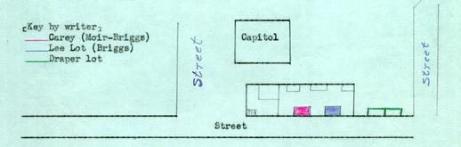 It seems entirely possible from the material consuled (tax records, insurance policies, and position of houses on the Frenchman's Map) to suggest that McCandlish bought first the house on the lot designated by writer as red; then he bought the house on the east (designated by writer as blue); and finally,
5
he bought the double-house lot in the unenclosed area (designated by writer as green).
It seems entirely possible from the material consuled (tax records, insurance policies, and position of houses on the Frenchman's Map) to suggest that McCandlish bought first the house on the lot designated by writer as red; then he bought the house on the east (designated by writer as blue); and finally,
5
he bought the double-house lot in the unenclosed area (designated by writer as green).
Just what happened to the buildings on the Draper lot after its incorporation into the McCandlish holdings is not known.1 Fire and war have been responsible for the destruction of many of the Williamsburg and James City County records. McCandlish or some member of his family are known to have held the lots until as late as 1885. Further history of the McCandlish lots can be found in the Moir house history, Research Department.
In 1931, the Architectural Department made excavations in this area. They uncovered foundation remains of a 20x66 foot building located near the corner of Waller and Francis Streets. From the uncovering, it seems that the large building had a basement under a part of the house. Photographs were taken from the foundation. (See photographs #N6414, #N6427, #6428 in Architectural Department.)
SUMMARY:
Unfortunately, no early records have come to light as to the ownership of this property. John Draper seems to have been there in 1791. Subsequent records (after 1791 when the name "Draper" appears on the "College Map" as owner of this lot) indicate that John Draper was mentioned as being located to the east of James Moir's lot. When Robert McCandlish came into the possession of the lot in 1821 via Alexnader D. Irvine and George Irvine, the tax records note as follows: "this property was charged heretofore to John Draper's estate." As the land tax records for Williamsburg listed Draper as owner of only one 6 lot, it seems reasonable to state that repairs made to Draper's property by Humphrey Harwood, carpenter and brick-mason, in 1784-1786 were for buildings upon this lot. The Frenchman's Map (1782) shows an oblong house with partition on this lot; and Bucktrout Map (1803) indicates the name "Draper" on the lot in question. After McCandlish's acquisition of the property, changes evidently occurred (thru fire, war or razing). Foundations uncovered in 1931 by the Architectural Department, Colonial Williamsburg, measured 20 by 66 feet, near the corner of the Waller and Francis Streets. From the foundations uncovered, it seems that th elarge building had a basement under a part of th ehouse. For further history of the property, see Moir house history filed in Research Department and chain of title filed in the Accounting Department, Colonial Williamsburg.
(Report prepared by Mary A. Stephenson, Research Assistant)
May, 1949.
Footnotes
In 1780, John Draper by deed from Samuel Major had come into "one lot. . .whereon the Old Play House lately stood. . ." (York County Records, Deeds, 6, p. 94.)
Illustration #1 Draper Lot
 Photostat Copy of the Williamsburg Plat in "Williamsburg the Old Colonial Capitol" by Lyon G. Tyler
From Frenchman's Map 1782?
Illustration #2
| Mr John Draper | Dr | ||
| 1784 | th | To Amt brt from folio 111 - Ledgr A | £17. 8 7½ [?] |
| March | 30 | To 1 bushel of Corn 5/. | " 5 - |
| 1785 | th | ||
| May | 29 | To 2 bushels of lime 2/. & 100 bricks 3/. | " 5 - |
| To laying an harth & mending chimney 5/. | " 5 - | ||
| To labours work 2/. | " 2. - | ||
| d | |||
| February | 2 | To 2 bushels of lime 2/. & 130 bricks 4/. & 2 days labr at 2/6 | " 11 - |
| To repairing 2 Chimneys & laying 2 hearths 10/. | " 10. - | ||
| July | 13 | To 40 bricks 1/3 Lime 1/3 for Mrs Draper & Repair. underping to Shop 3/. & labr 1/3 | 6.6 [?] |
| 1786 | |||
| April | 6 | to 1 bushel of Oats 2/6 July 8th 10 bushs lime 10/. & 350 bricks 10/6 | 1 3. |
| July | 8 | To Underpining Stable 15/. & 2 days labr a 2/6 | 1 0. - |
| £21.16.1½ |
Carried to Folio 95
(Harwood Ledger B, p. 42)| Mr John Draper's Estate | Dr | ||
| 1786 | th | ||
| Novemr | 19 | To 28 bushels of lime a 1/. & 1034 Bricks a 3/. & 4½ days labr a 2/6 | 3.10.3 |
| To building a pair of front Steps 15/. & laying a floor 6/. | 1. 1. - | ||
| To mending Cellar Wall & pillars to portch & plasterg 6/. | - 6. - | ||
| 1787 | |||
| June | 10 | To 21½ bushels of lime a 1/. & underpining Necessary 5/. | 1. 6.6 |
| To repairing plastering 15/. | -15. - | ||
| To do Back & underpining to House 4/6 | - 4 6 | ||
| To Labours Work 5/. | - 5. - | ||
| £29 4.4½ |
|---|
Illustration #3
WILLIAMSBURG LAND TAX RECORDS
| 1782 | John Draper | 1 lot | £4.4.- | value |
| 1786 | John Draper | 1 lot | £12.-.- | value |
| 1790 | John Draper Est. | 1 lot | £8.-.- | value |
| 1798 | John Draper Est. | 1 lot | $26.67 | value |
| 1807 | John Draper Est. | 1 lot | $30.00 | value |
| 1819 | John Draper Estate | 1 lot | $30 | value |
| 1820 | John Draper Est | 1 lot in fee | $200 | value of lot |
| $100 | sum added on account of buildings | |||
| 1821 | Robert McCandlish | 1 lot in fee | $200 | value of lot |
| $100 | sum added on account of buildings Via Alexander D. Irvine for himself & also in part for his brother George Irvine - this property was Charged heretofore to John Draper's Estate. |
1861 [Robert McCandlish was the owner of 5 lots in Williamsburg. This was included in the 5 lots. See house history.]